Showing posts with label landscape. Show all posts

Tuesday, June 19, 2012

The Grand Canyon, Going Down is Optional

The guys admiring the view at Ooh Aah Point - seriously I didn't pose them 
and I didn't name the location either

Our descent into the Grand Canyon via the South Kaibab Trail was... well... let's just call it rough. Lest this be misconstrued as complaining, I'll start off by saying that it's all totally worth it! Exhibit A:
You can actually see where we took the picture of all of us in this collage - that hump on the second picture from the left is the same hump in the background of the previous picture.
The South Kaibab trail is not for the faint of heart. It's hot. The blistery wind whips up the red dust and brushes it like sandpaper against your skin. Almost no shade and no water add to the delights of the almost constant decline of the path. I took precautions for all of these things: carrying at least 4 liters of water, wearing long pants, long-sleeve shirt, and bandana around the neck to safeguard my face through the dust storms, and training by hiking the 9 story parking garage for weeks before the inevitable. However, the almost constant strain on my knees (I wore braces the whole time) and constantly tightening my boots to prevent my toes slipping into the front of my boots over and over again, coupled with my own problem of not drinking quite enough - the bathrooms are too far apart - made it my least favorite day. The phrase "it's all uphill from here" really fit for me.

 A Century Plant (only blooms once just before it dies) 
I literally had my arms raised all the way as I was standing on a rock to get this picture
 I don't know how tall these things get, but this one was easily 2X my height. Fortunately it was bending over so I could get under it to take this photo.

Fortunately, amazing views the whole route and the exciting prospect of a wonderful stew meal at the bottom got me through. (Last time we did this - six years ago - the hike down wasn't so bad, except for the last mile that Mike and I ran - yes literally ran with a 30-40 lb backpack - to get to the ranch in time for dinner, but the struggle getting out was so much worse for me as a result. Also, it actually rained on us in 2006 and the cloud cover made it more bearable.) At any rate, we did this trail in record time - for us - with my dad always the first to get our butts moving after a break, and an overwhelming urge to get out of the heat, I think it only took us like 5-6 hours!

Not quite a 360 ° panorama (click on the image to enlarge it)

The fact that we made it to the campground in the early afternoon turned out to be a really REALLY good thing. We were too late for the best campsites, but we got there before the second break in the water line washed away a good portion of the trail. Had we arrived later, we would've had to backtrack and come around a different - longer - way. The breaks in the water line did affect us. Those who were staying at the ranch were more inconvenienced in that their promised showers were taken away. As it was, there was only one place to get fresh drinking water and all flush toilets required carrying a bucket full of creek water into the restroom with you and pouring that into the toilet to get it to flush.

 Our first view of the Colorado River - probably a little more than half-way to the bottom!

All meals were still served and fun was still had. After a delicious stew meal where we met new friends and shared tales of journeys had and yet to have, we went to a ranger talk about the geology of grand canyon - Grand Canyon ROCKS! - and then attempted to sleep in our hot tents as the wind pushed the dust through the screens. Those who did get to sleep woke up covered in a thin layer of red sand. I, however, was glad to have a view of the moon and stars as I lay awake wondering if it would ever cool off enough to get to sleep.

Next up: A Day at the Bottom!

This is a series on our 2012 trip. In case you missed it, here is my first post:
All photos copyright Katrina Kouba Boles

Monday, February 13, 2012

Timelapsed Progress of Glacial Recession - Week 3

Alas, another week gone by, fortunately my progress has continued to pick up. Once again, I've captured the dyeing and design process of Glacial Recession. This is the last week I'll be recording the work done in the dye/printing room. But, I intend to continue to record the process of layout and design.

Previous posts on this:
Glacial Recession - starting the project
Week 1 - Creative two-ways
Week 2 - Design and Dye

Thursday, February 2, 2012

Design and Dye - Week 2 of timelapsing my art

I got a lot of encouragement from a couple of fantastic people who said they really enjoyed watching my timelapse last week. So, on Saturday, after I'd decided I wouldn't be doing any more timelapses in the studio and headed out to the garage to do some spray-bottle dying, when I came back downstairs and started hanging fabric on the wall, I just couldn't stop myself. Can we say narcissistic? Anyway, most of this week was spent in the printing room, where I experimented with rolling thickened dye on, printing it on wet fabric, and using salt to attempt to get the fabrics for this piece. It's been touch and go as my frustration at trying to get a blue gray surmounted to a new decision that the sky is just not going to have gray. I really loved the texture I got from rolling the dye on, but didn't want to just do that. And the printed texture of leaves and trees are quite lovely once the actual images turn into texture rather than the specific images they started out as. Finally, I managed to control the dye/salt mixture to start getting some really interesting results.


And, I am trying out a new way of rinsing the dyes, which I found on Vicki Welsh's blog.

Friday, January 27, 2012

Creative two-ways

Every year on vacation, I "have" to get one timelapse of a sunrise and one of a sunset. It started in Glacier, the first vacation I had a video camera. Now that I have a new DSLR camera and got a timer for Christmas, I figured I need to learn to work the thing. Here's my second attempt at a timelapse (the first attempt is so bad it's not worth keeping):


So by now you're probably wondering where the second way I've been creative comes in... Well, lately have been frustrated by my big quilt that I began finally really working on last fall (Glacial Recession), but that hasn't kept me out of the studio this week. With all my curiosity about making good timelapses,  wouldn't you know it, I came across a video of a timelapse of a painter in her studio. One thing led to another, and voila, I couldn't stop myself. Once I had the timer going, I had to do SOMETHING. So here you have it, a timelapse of me working in my studio not quite every day, but often enough...


Y'know, I really should put some music under this for interest....oh well, next time.

Monday, December 19, 2011

Washington DC - the National Mall

The national mall is a deceiving in it's size. We certainly got our exercise enjoying the scenery and visiting the museums.
 View from the National Mall nearing sunset
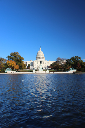
 The US Capitol


 The Lincoln Memorial
The World War II Memorial and the Lincoln in the background, after sunset

We were grateful to have our friends join us for two days of sightseeing and museum touring. We enjoyed the Air and Space, Natural History, American History, Art History (I visited this one on my own and will post photos of my favorite pieces next), and the Air and Space Udvar-Hazy Center.

All photos copyright Katrina Kouba Boles

Sunday, November 20, 2011

Washington DC - part 1

The week of Halloween this year we traveled to our nation's capital for work. Two days before setting off, I got a new camera!! Of course, along the way, I had to learn how to use it and what better way than to attempt to get photos of passing scenery. In particular, on the morning of October 30th, after the Northeastern US got pummeled with snow, the sun came out in all its glory, shining through the foggy, cloudy sky. Boy was it beautiful!! Thankfully, some of my pictures came out in focus:


These were all taken somewhere between Morgantown WV and Washington DC.

All photos copyright Katrina Kouba Boles

Tuesday, August 16, 2011

Hiking to Observation Point, Zion NP, Utah

While last year we really loved hiking to Angel's Landing, we decided with only one full day in Zion, that perhaps we ought to do another trail with spectacular vista views. Of course, we opted for a harder trail than last year.

Sidenote: last year Zion was one of the last parks we visited, knowing that we'd want to attempt the nearly 5-mile and 1488 ft ascension to the peak, and worked up our stamina to be able to do it. I guess I figured since we managed the 7-mile and 1100 ft ascension at Harney Peak merely days before, that we'd be fine doing a harder and longer trail.

The trail to Observation Point begins at the Weeping Wall trail-head and it starts climbing almost immediately. This trail is an 8-mile round-trip with a 2147 ft ascension and is not for those who are afraid of heights. However it's almost entirely paved and switchbacks make it do-able.
It begins with a series of switchbacks that quickly lead you up the side of the rock-face,  producing more and more beautiful views at every turn.
This is the last view of the main canyon for a while as the trail bends southeast into Echo Canyon. Having done little research for this particular trip to Zion, I did not realize that the canyon would narrow into a slot canyon, delving 20ft down a very narrow passageway. Frankly, this was one of our favorite parts of this hike. Maybe because it was unexpected?

Once you leave the narrow section of Echo Canyon, the trail begins ascending again up the north side of Echo Canyon and the views are of the primarily white canyon walls where trees and shrubs precariously grow, providing little shade in this arid and bright landscape.
(This photo was actually taken on our way back, but I wanted to show the trail etched into the cliff.)

Relief from the climb came in the last mile or so to observation point. It was mostly flat and occasionally provided some shade. There were several times where the view seemed spectacular enough to stop and head back, but then the trail led into an area of brush where the view is less interesting, and suddenly out of the brush and voila: 270 degree panoramic views.
Mike had fun pulling out his binoculars to see if he could spot people on Angel's Landing, which seemed a lot higher up when we were there last year - and a LOT more crowded. That place would've looked like an ant hill with the swarms of people. This year we saw very few over there.

So it took us about 3 hours to hike to Observation Point, we spent an hour at the point, just soaking in all the views (thankfully my camera also did some soaking so my brain would not have to remember it all), and then the two hour hike back down would inevitably come back to haunt us the next day.

We were too tired to cook, so in the name of a new tradition, we went back to have pizza at Springdale's Pizza and Noodles restaurant where we could sit outside and enjoy our food.

Feel free to comment. If you've been to Zion, I'd love to know what you saw and if you'd recommend other hikes. Though I have a hard time wanting to go back to parks I've already seen - there are just so many and I want to see them ALL - I could go back to Zion. It's so beautiful.

Photos copyright Katrina Kouba Boles

Next up: Bryce Canyon NP, Utah

This is a series on our 2011 trip. Here are the previous posts:

Friday, July 29, 2011

Day 4 in Yellowstone NP

On our final day at Yellowstone, we headed off to see the park's most famous feature - Old Faithful. For those of you who don't know, Old Faithful is located in the Upper Geyser Basin, an area that has a lot of thermal activity and several interesting features. On our way to the Old Faithful area, we stopped at Kepler Cascades.

After three nights of camping, we figured it was about time for showers, so we first headed to the Old Faithful Inn (I wasn't really eager to try the showers at the Fishing Bridge RV park...it looked a little dodgy and expensive for what we'd get). For anyone who's considering camping in Yellowstone and possibly concerned about the shower situation, the Old Faithful Inn was a great place to shower. It was inexpensive, you can buy soap and rent towels, and it was very clean and nice. For anyone visiting this area, regardless of whether you need a shower or intend to stay the night, at least take the trouble to go into the main lobby of this historic inn, as it is really something else. Check out my 360 panorama in Photosynth from the lobby:

Here's another way of viewing the lobby image:

Mike finished showering first and I found him out on the patio, sitting in the shade with a darn good view of Old Faithful. He got there just in time to see the eruption. I got there just as it ended. Oh well, I figured, I've seen it before and most likely will get to see it again...little did I know we'd spend all day waiting and watching geysers, including Old Faithful.

The boardwalk of the Upper Geyser Basin is jam-packed with geysers, and it seems like the only way you could miss seeing a single geyser eruption would require both bad luck and a super quick perusal.
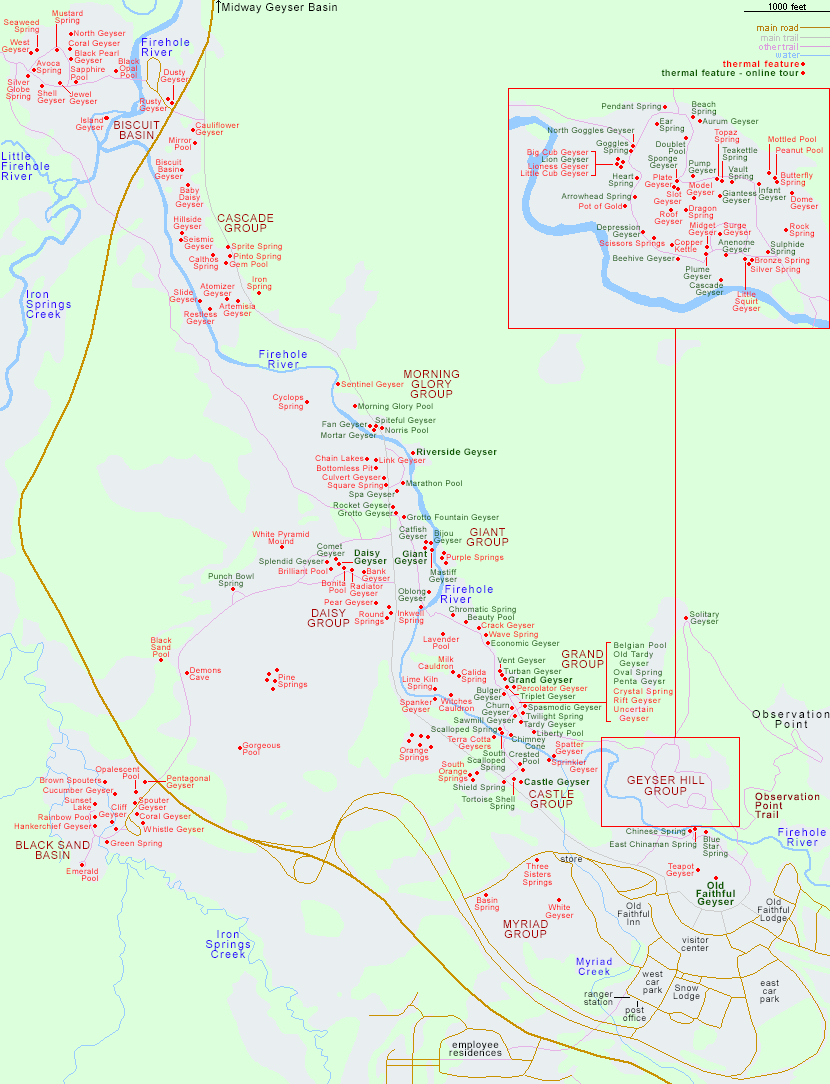
Map of the Upper Geyser Basin from The American Southwest
We walked from Old Faithful to Castle Geyser, as Castle is one of the predictable large geysers, and I wanted to see what time we might get to see it (around 8 pm that day), and then up to Grand Geyser, another large predictable geyser. We got there right at the middle of the expected eruption window, sat and watched for a while, then got restless. We saw Sawmill, Penta, Spasmordic, and Grotto geysers erupting. I suspect during the two hours we decided to wait for Grand, we were also seeing the smaller eruptions of Turbine Geyser.
Penta Geyser, Yellowstone National Park
And then, in the last two minutes of the predicted eruption window, Grand put on a show, spraying boiling water and steam to a height of 180-200 feet for 12 minutes. This fountain geyser looks much different from other geysers in it's eruption because of how it erupts from a pool, spraying water outward in addition to upward. Grand, the world's tallest predictable geyser, performs for a short time, then acts like it's done for about a minute, and then the water shoots out at it's peak.
Grand Geyser, Yellowstone National Park
Photo by Mike Boles
 Grand Geyser, Yellowstone National Park
After Grand's eruption, it was two hours past lunchtime, so we headed off to find some food. After lunch, we went to the "new" welcome center (it's new since the last time I was at Yellowstone, 10 years ago, but I don't know when it was built). We watched an unremarkable introductory video, then felt better about our own abilities when it comes to creating motion media. They time the video to show about 10 minutes before an Old Faithful eruption, so we headed outside to watch. Once again, the geyser waited until the last couple of minutes of the eruption window.

We hurried off to the ranger talk beginning at Castle geyser, and enjoyed that. There was a lot of information given on that talk, though I think we'd already gathered some of it from the previous ranger talk and reading all the signage about individual thermal features. One thing that we got from this talk and nowhere else was why the arid landscape was littered with little mounds of grass...buffalo dung. Perfect picture of a cycle: buffalo eat grass, poop out unneeded nutrients, grass grows in the dung, buffalo eat the grass...

After the talk, it seemed time for dinner, but it was also nearing sunset and another Old Faithful eruption. There were some people sitting out on the benches, none over where the sunset could be seen behind the geyser. Instinctively, I thought, why not sit there with the sun in our eyes, yes, but when the geyser erupts we'll get a very different view of it than what you typically see. On every vacation I try to get at least one time-lapse of a sunrise, and at least one of a sunset. By this point I was 0 for 2. Why not find out what the sunset would look like behind an eruption. It meant missing Castle Geyser's eruption, but I think it was worth it:
 Old Faithful, Yellowstone National Park
Old Faithful, Yellowstone National Park,
Photo by Mike Boles
Unfortunately, it's hard for photographs to really capture how interesting how the light was changing during this eruption, but typically before the sun hits the horizon, it can be really hard to look directly at it without clouds or something blocking it. In this case, it was boiling water and hot steam. And it was really quite awesome.

Unless otherwise noted, all photos copyright Katrina Kouba Boles

Sidenote: If you are interested in any of my puzzle photos, I often get them printed in poster-size and would be happy to sell one to you. I have many more from other vacations and locations as well. Send me a note or post one here and we can chat. Perhaps I'll share more of the ones from previous trips in another blog.

Next up: Sunrise at Yellowstone, Grand Teton NP and a change in plans

This is a series on our 2011 trip. Here are the previous posts:

Monday, June 27, 2011

Hiking in the Black Hills AKA Custer State Park

This year, on our way to Yellowstone and Grand Teton National Parks, we did a two-day stop-over in the Black Hills of South Dakota. Our first day we did some driving and some relaxing, as it was our two-year anniversary. We enjoyed a visit to the Needles and a stint on the 1880 steam train.


During our planning of this trip, I attempted to look into the best hikes for each of the places we were to visit. It was strangely difficult to find information online for the best hikes in the Black Hills. And so we did only one major hike in Custer State Park. According to my research, trail #9 from Sylvan Lake to Harney Peak is the most popular trail in the park. The USDA Forest Service considers it a moderate 3.5 mi trail with elevations of 6100-7200 ft. So you can imagine my surprise that we only saw about five groups of people on that trail. It felt like we had the Black Elk Wilderness to ourselves. Granted, we were visiting a bit pre-season (May 31), and started out in the late morning. Compared to other hikes we have done with similar elevation changes, this was aptly named a "moderate" hike.
For most of the trail we were hiking through pine forests, but a couple of times we came to overlooks of the hills in all their black-ness.

The last ascension is a climb of over 100 steps on a rock stairway, but the view from the former fire lookout is well worth the extra stops to catch your breath.

Rather than return by the same route, we took the left fork when the path splits on trail #3, which connects to trail #4. From trail #4 we had some beautiful views of the Cathedral Spires.

There is a turn-off to Little Devil's Tower, which is another mile from the main trail we traveled, and since our full hike was already going to be about 7.5 miles, we decided not to veer. Most of these folks were headed to Little Devil's Tower, but if just our one experience of these two hikes would tell us the most popular hike in the park, I would guess it to be trail #4 rather than #9. We did meet with some people who'd ventured trail #9 just a few days before. They said they experienced snowfall at the peak. So we were grateful for the beautiful skies and lack of precipitation in our experience of Harney Peak. I would recommend to anyone venturing this hike to be prepared with raingear and warm clothing. Though no clouds decided to open up upon us, we did endure quite a lot of gusty wind. I would also say that the route we took - up to the peak on #9 and down on #4, was the best option as the ascent on #9 felt more gradual than the descent on #4, plus if one were traveling the other way, you'd have to turn round to see the spires and could therefore miss them by chance.

And by the way, I did take a few "normal" pictures, but what fun are those! Stay tuned...more on vacation, hiking, and crazy images: little planets, panoramas, and puzzles!

All photos copyright Katrina Kouba Boles.

Next up: Devils Tower and Little Planets

Monday, August 30, 2010

Utah Landscapes

It seems fitting that I post some favorite photos from our vacation this past May since I've been slowly wading through them over the past couple of days. We'll start off with some favorite landscapes from Utah.
Atop a Fin at Arches National Park, by Katrina Boles
Double O Arch at Arches National Park, by Katrina Boles
Owachomo Bridge at Natural Bridges National Monument, by Mike Boles
Capitol Reef National Park, by Katrina Boles
Sheltered Tree in a Cohab Canyon Slot Canyon at Capitol Reef National Park, by Mike Boles
First Hoodoo sighting at Bryce Canyon National Park, by Katrina Boles
Queen's Garden Hoodoos at Bryce Canyon, by Mike Boles
View from under Weeping Rock at Zion National Park, by Katrina Boles
Hiking to Angel's Landing in Zion National Park, by Mike Boles
Angel's Landing Trail at Zion National Park, by Mike Boles
View from Angel's Landing Descent at Zion National Park, by Mike Boles

As I continue to sort through the photos, I hope to post more favorites...rock formations, primitive art, flowers, sunrise/sets, as well as landscapes from Colorado and Arizona.