

uniting environmentalism, design, textiles and inspiration
Showing posts with label little planets. Show all posts
Showing posts with label little planets. Show all posts
Thursday, July 4, 2013
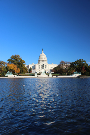
United States Capitol little planet
In honor of Independence Day, here's the little planet I created from our time in 2011. Head on over to my photo manipulations site if you want to purchase a print. Enjoy the holiday!

Saturday, April 13, 2013
New Mizzou Little Planet
When I originally posted some of my first little planets, I had no idea they'd be so popular. And so I have re-done the Mizzou Little Planet, using a better camera and other techniques to make it look better (it also helps to not have someone running through the shots). Here is the updated Francis Quadrangle little planet:
 To purchase a print, visit photosbykatrina or contact me by email or in the comments.

Monday, December 19, 2011
Washington DC - the National Mall
The national mall is a deceiving in it's size. We certainly got our exercise enjoying the scenery and visiting the museums.


View from the National Mall nearing sunset
The US Capitol


The Lincoln Memorial

The World War II Memorial and the Lincoln in the background, after sunset
We were grateful to have our friends join us for two days of sightseeing and museum touring. We enjoyed the Air and Space, Natural History, American History, Art History (I visited this one on my own and will post photos of my favorite pieces next), and the Air and Space Udvar-Hazy Center.
All photos copyright Katrina Kouba Boles
Friday, September 16, 2011
To be in the Studio or on the computer?
Originally I began blogging last year as a way to get myself to continually look for inspiration and I created it as a place to put that inspiration for my own self-reference. Furthermore, often when I come across things that I find inspiring I can't wait to share them with people. Voila: blog. Lately this blog has also taken on another purpose: it's a place for me to share the personal creative work I've been doing. It also happens to be inspirational to me, so I see it as a WIN-WIN.
Though I have been working on personal projects, they've mostly been digital, which means my studio time has diminished to almost nothing. This makes me sad. The other day I was shopping at the fabric store, getting some muslin to begin dyeing new curtains... again (my first attempt with the snow dyes was less than fantastic and my second attempt was less than spectacular as well), and I found the perfect fabric for a skirt I've been wanting to make. I decided not to let myself get the fabric because I already have at least half a dozen garment projects at home waiting for my attention. I told myself if I made one of those then I could go out and buy the fabric. So on a Friday afternoon, I stopped by the library to get some audio books on my way home, and spent the weekend sewing a shirt together.
I listened to one of these books twice, and have since listened to it again. It's right up there with the Elizabeth Gilbert TED talk that I go back to often, which I have previously blogged about. The book is called Ignore Everybody and 39 Other Keys to Creativity by Hugh MacLeod. You can download the earlier version of his book for free and keep up with him on his blog.
Anyway, what I want to talk about here is the connection I made to one of the things Hugh MacLeod talks/writes about: Putting the hours in. This is where he mentions not being worried that someone might rip-off his idea of drawing on business cards because he does it for his own satisfaction and he's done so many of them that no-one could really overtake him in the sheer numbers produced AND it would be less satisfying for them because of whatever crazy reasoning they put behind it. I am relating to this in my process of creating puzzle photos as well as my more recent little planet creations (though sometimes I think of them as marbles because that's what they look like to me: a moment of time and space trapped in a glass sphere). Was I the first to come up with either of these ideas? No. And I probably won't be the last. My process has become my own and with each one I do, that process changes just a little bit. I create them for my own satisfaction.
I've been doing these puzzle photos for six years now, so I have quite a collection of them, and I'm always trying to figure out how to make them better. Sometimes I just don't get why one didn't work. Typically I can't really tell when I'm taking the photos how the final composition will look, so I've taken to increasing the number of photos and angles I take, which means that I end up producing even more of these final puzzles.
Well I've finally put all my puzzles and little planets from 2011 in one place: in my behance portfolio and I'm working on including all the puzzles I created from 2005-2010.
Tuesday, September 6, 2011
Bryce Canyon, NP, Utah
After taking the Observation Point trail too quickly on our way back to camp the day before, hiking in Bryce Canyon was a challenge. But here's the thing: typically I like to hike up first and down on the way back, but when you're hiking into a canyon it just doesn't work that way. Yet, after such a hike, it was painful hiking into the Bryce amphitheater (it's not really a canyon), and coming out was much much easier!
We've finally learned our lesson about paying for more than one day at a campsite, and though we'd planned to spend two nights in Bryce, we paid only for one in case we changed our minds - which we did. Anyway, after we found the spot we wanted at the sunset campground, we walked up to catch the bus out to Bryce Point.


As we descended, there were numerous panoramic moments.


Once we were at the bottom, most views were hindered by trees and "dead" hoodoos. However, wall street (two really tall fins that haven't yet eroded into arches or hoodoos) was pretty cool.


We were lucky I guess. Last year we hiked the Navajo to the Queen's Garden loop, and since the wall street side of Navajo was closed, we went down the thors hammer side. This year, the opposite was true: thors hammer was closed so we got to do the wall street side. Amazingly, I made it up the 20+ switchbacks out of wall street with only one short stop in the middle. I guess I was pacing myself and had gained some muscle endurance on all our other hikes this trip.
The next morning we got up early to see the sunrise from sunrise point.

Though we should've been prepared, we didn't expect it to be as cold as it was. One hour of waiting and watching, then we packed up our campsite and drove to see the south end of the park before heading to Colorado.

Here marks the end of our national parks tour for this trip. We loved the beautiful sights we got to enjoy and I've really had fun making all the collaged photos and little planets. The last days of our trip were spent driving and a two-day stopover in Boulder, CO. There, we relaxed, went to a movie, and I spent some time in the Butterfly Pavilion, which was awesome! So, stay tuned...
Photos copyright Katrina Kouba Boles
This is a series on our 2011 trip. Here are the previous posts:
We've finally learned our lesson about paying for more than one day at a campsite, and though we'd planned to spend two nights in Bryce, we paid only for one in case we changed our minds - which we did. Anyway, after we found the spot we wanted at the sunset campground, we walked up to catch the bus out to Bryce Point.

Bryce Point, Elevation 8300 ft
The plan was to take the Peek-a-Boo trail to the Navajo trail and come out through wall street at the sunset point parking lot. The Peek-a-Boo trail took us down into the amphitheater, through arches and switchbacks.
As we descended, there were numerous panoramic moments.


Once we were at the bottom, most views were hindered by trees and "dead" hoodoos. However, wall street (two really tall fins that haven't yet eroded into arches or hoodoos) was pretty cool.


We were lucky I guess. Last year we hiked the Navajo to the Queen's Garden loop, and since the wall street side of Navajo was closed, we went down the thors hammer side. This year, the opposite was true: thors hammer was closed so we got to do the wall street side. Amazingly, I made it up the 20+ switchbacks out of wall street with only one short stop in the middle. I guess I was pacing myself and had gained some muscle endurance on all our other hikes this trip.
The next morning we got up early to see the sunrise from sunrise point.

Though we should've been prepared, we didn't expect it to be as cold as it was. One hour of waiting and watching, then we packed up our campsite and drove to see the south end of the park before heading to Colorado.

Here marks the end of our national parks tour for this trip. We loved the beautiful sights we got to enjoy and I've really had fun making all the collaged photos and little planets. The last days of our trip were spent driving and a two-day stopover in Boulder, CO. There, we relaxed, went to a movie, and I spent some time in the Butterfly Pavilion, which was awesome! So, stay tuned...
Photos copyright Katrina Kouba Boles
This is a series on our 2011 trip. Here are the previous posts:
Tuesday, August 16, 2011
Hiking to Observation Point, Zion NP, Utah
While last year we really loved hiking to Angel's Landing, we decided with only one full day in Zion, that perhaps we ought to do another trail with spectacular vista views. Of course, we opted for a harder trail than last year.
Sidenote: last year Zion was one of the last parks we visited, knowing that we'd want to attempt the nearly 5-mile and 1488 ft ascension to the peak, and worked up our stamina to be able to do it. I guess I figured since we managed the 7-mile and 1100 ft ascension at Harney Peak merely days before, that we'd be fine doing a harder and longer trail.
The trail to Observation Point begins at the Weeping Wall trail-head and it starts climbing almost immediately. This trail is an 8-mile round-trip with a 2147 ft ascension and is not for those who are afraid of heights. However it's almost entirely paved and switchbacks make it do-able.
 It begins with a series of switchbacks that quickly lead you up the side of the rock-face, producing more and more beautiful views at every turn.
 This is the last view of the main canyon for a while as the trail bends southeast into Echo Canyon. Having done little research for this particular trip to Zion, I did not realize that the canyon would narrow into a slot canyon, delving 20ft down a very narrow passageway. Frankly, this was one of our favorite parts of this hike. Maybe because it was unexpected?


 Once you leave the narrow section of Echo Canyon, the trail begins ascending again up the north side of Echo Canyon and the views are of the primarily white canyon walls where trees and shrubs precariously grow, providing little shade in this arid and bright landscape.

 (This photo was actually taken on our way back, but I wanted to show the trail etched into the cliff.)
Relief from the climb came in the last mile or so to observation point. It was mostly flat and occasionally provided some shade. There were several times where the view seemed spectacular enough to stop and head back, but then the trail led into an area of brush where the view is less interesting, and suddenly out of the brush and voila: 270 degree panoramic views.


 Mike had fun pulling out his binoculars to see if he could spot people on Angel's Landing, which seemed a lot higher up when we were there last year - and a LOT more crowded. That place would've looked like an ant hill with the swarms of people. This year we saw very few over there.
So it took us about 3 hours to hike to Observation Point, we spent an hour at the point, just soaking in all the views (thankfully my camera also did some soaking so my brain would not have to remember it all), and then the two hour hike back down would inevitably come back to haunt us the next day.
 We were too tired to cook, so in the name of a new tradition, we went back to have pizza at Springdale's Pizza and Noodles restaurant where we could sit outside and enjoy our food.
Feel free to comment. If you've been to Zion, I'd love to know what you saw and if you'd recommend other hikes. Though I have a hard time wanting to go back to parks I've already seen - there are just so many and I want to see them ALL - I could go back to Zion. It's so beautiful.
Photos copyright Katrina Kouba Boles
Next up: Bryce Canyon NP, Utah
This is a series on our 2011 trip. Here are the previous posts:
Sidenote: last year Zion was one of the last parks we visited, knowing that we'd want to attempt the nearly 5-mile and 1488 ft ascension to the peak, and worked up our stamina to be able to do it. I guess I figured since we managed the 7-mile and 1100 ft ascension at Harney Peak merely days before, that we'd be fine doing a harder and longer trail.
The trail to Observation Point begins at the Weeping Wall trail-head and it starts climbing almost immediately. This trail is an 8-mile round-trip with a 2147 ft ascension and is not for those who are afraid of heights. However it's almost entirely paved and switchbacks make it do-able.


Relief from the climb came in the last mile or so to observation point. It was mostly flat and occasionally provided some shade. There were several times where the view seemed spectacular enough to stop and head back, but then the trail led into an area of brush where the view is less interesting, and suddenly out of the brush and voila: 270 degree panoramic views.


So it took us about 3 hours to hike to Observation Point, we spent an hour at the point, just soaking in all the views (thankfully my camera also did some soaking so my brain would not have to remember it all), and then the two hour hike back down would inevitably come back to haunt us the next day.

Feel free to comment. If you've been to Zion, I'd love to know what you saw and if you'd recommend other hikes. Though I have a hard time wanting to go back to parks I've already seen - there are just so many and I want to see them ALL - I could go back to Zion. It's so beautiful.
Photos copyright Katrina Kouba Boles
Next up: Bryce Canyon NP, Utah
This is a series on our 2011 trip. Here are the previous posts:
Thursday, August 4, 2011
Grand Teton NP


Photos copyright Katrina Kouba Boles
Next up: Zion NP, Utah
This is a series on our 2011 trip. Here are the previous posts:
Sunrise at Yellowstone


Frost on Fishing Bridge, Yellowstone NP
Photo by Mike Boles
Unless otherwise noted, all photos copyright Katrina Kouba Boles
Next up: Grand Teton NP
This is a series on our 2011 trip. Here are the previous posts:
Wednesday, July 20, 2011
Day 3 in Yellowstone NP
On June 4 we moved our camp from Madison to Bridge Bay Campground. On our way there, we stopped at the Artist Paint Pots area to walk the boardwalk. From a viewpoint above:


Once we got to Bridge Bay we discovered that our site was under a couple feet of snow, so we had to find one they could give us with a dry spot for our tent. Fortunately we found one:
 By this time it was well past lunch time and we chose to drive out toward Yellowstone lake to eat something. Another set of PB&Js... But the lake, also covered in snow, was quite a place to view. The waves of snow were particularly curious, as were the melted spots (from thermal features under the lake).


Sadly, because of all the snow and runoff, the only hiking we realized we'd get to do would be on the boardwalks. So, to more thermal features we went.

At the mud volcano boardwalk we managed to meet up with a ranger talk just after it had started. It was a really engaging ranger talk about change and how this park is constantly changing. The features change, and even a feature that seemed to never change at some point went from a lake that trappers used as a bathtub to a highly acidic "sour" lake. We were also fascinated to learn about the buffalo; and he impressed upon us all that we should not take them to be stupid and slow. They are quite the contrary, able to run at speeds up to 35 mph, to clear a fence in a bound from standing, and people have been killed by them.
After the guided walk, we headed off to see the upper and lower falls of the Yellowstone River. Starting at the Upper Falls viewpoint, we'd hoped to take the trail to the Lower falls, but it was covered totally in snow along the cliff, and it was getting dark. So we took pictures, then drove to another lookout of the Lower Falls.


We had thought maybe we'd be able to return during the day and hike if we decided to stay two more days in the park, but we changed our plans and headed to Grand Teton a day early. Next up...our final day at Yellowstone with the most famous geyser.
All images copyright Katrina Kouba Boles
Up next: Day 4 in Yellowstone NP
This is a series of posts following our vacation. Easy access to previous posts:


Once we got to Bridge Bay we discovered that our site was under a couple feet of snow, so we had to find one they could give us with a dry spot for our tent. Fortunately we found one:


Sadly, because of all the snow and runoff, the only hiking we realized we'd get to do would be on the boardwalks. So, to more thermal features we went.

At the mud volcano boardwalk we managed to meet up with a ranger talk just after it had started. It was a really engaging ranger talk about change and how this park is constantly changing. The features change, and even a feature that seemed to never change at some point went from a lake that trappers used as a bathtub to a highly acidic "sour" lake. We were also fascinated to learn about the buffalo; and he impressed upon us all that we should not take them to be stupid and slow. They are quite the contrary, able to run at speeds up to 35 mph, to clear a fence in a bound from standing, and people have been killed by them.
After the guided walk, we headed off to see the upper and lower falls of the Yellowstone River. Starting at the Upper Falls viewpoint, we'd hoped to take the trail to the Lower falls, but it was covered totally in snow along the cliff, and it was getting dark. So we took pictures, then drove to another lookout of the Lower Falls.


(this is my first attempt at creating a high dynamic range - HDR - puzzle image)
All images copyright Katrina Kouba Boles
Up next: Day 4 in Yellowstone NP
This is a series of posts following our vacation. Easy access to previous posts:
Tuesday, July 12, 2011
Day 2 in Yellowstone NP
Day two in Yellowstone was a beautiful day: much less windy though still on the cool side. With a good part of the park still covered with snow (it was the first week of June), we headed North to the Tower-Roosevelt part of the park, where rangers had pointed out a few hikes not under snow or water. One of those hikes was the Hellroaring Trail and on our way to the Hellroaring parking lot, we stopped at Gibbon, Rustic, Undine and Wraith falls.


The Hellroaring trail, used also for backpacking, drops for the first section down to the suspension bridge over the Yellowstone River, then through a wooded area followed by a sagebrush plateau. The 4 mi (round trip) day hike is intended to end at the Hellroaring Creek, but we turned around early as the signs were not giving us directions to the Creek. We suspect that at the final junction (based on the map) we should head to the left, but a group of bison were in that direction, and with other groups of bison further up from where we came down the plateau, we opted to head back. It felt for the most part like we had the trail to ourselves. We passed a few backpackers and started off behind a group of day hikers, but otherwise it was just the two of us. Since Yellowstone is bear country, we did a lot of talking and fortunately if any animals were around, they were warned off by our voices. The ascent at the end of the hike was a workout for our legs and warm in the sun, but certainly not unbearable.


After the hike, we drove to Tower Falls. Unfortunately, the trail to the bottom of the falls was closed, so we were only able to see it from the lookout above. The last time I was in Yellowstone, ten years ago, the hike to the bottom of Tower Falls was one of the few non-boardwalk trails we actually did, but it was later in the summer and the falls were not as full.

On our way back, and just a few miles from Mammoth, there were a slew of cars parked along the road, which usually means one thing: bear. So we had to join the crowd, and after much careful searching, we spotted what everyone else was seeing: a bear and an elk acting strange. Several onlookers were certain the elk had a calf hidden in the brush somewhere and she was trying to lure the bear away. As the bear got farther and farther away, I decided I really didn't want to see it catch the calf and we headed the rest of the way back to our campsite.
All photos copyright Katrina Kouba Boles
Next up: Day 3 in Yellowstone NP
This is a series on our 2011 vacation. Here are the previous posts:

Gibbon Falls, Yellowstone National Park

Rustic Falls, Yellowstone National Park

Yellowstone National Park

Undine Falls, Yellowstone National Park

Wraith Falls, Yellowstone National Park

The Hellroaring trail, used also for backpacking, drops for the first section down to the suspension bridge over the Yellowstone River, then through a wooded area followed by a sagebrush plateau. The 4 mi (round trip) day hike is intended to end at the Hellroaring Creek, but we turned around early as the signs were not giving us directions to the Creek. We suspect that at the final junction (based on the map) we should head to the left, but a group of bison were in that direction, and with other groups of bison further up from where we came down the plateau, we opted to head back. It felt for the most part like we had the trail to ourselves. We passed a few backpackers and started off behind a group of day hikers, but otherwise it was just the two of us. Since Yellowstone is bear country, we did a lot of talking and fortunately if any animals were around, they were warned off by our voices. The ascent at the end of the hike was a workout for our legs and warm in the sun, but certainly not unbearable.

View from Yellowstone River Suspension Bridge, Yellowstone National Park

After the hike, we drove to Tower Falls. Unfortunately, the trail to the bottom of the falls was closed, so we were only able to see it from the lookout above. The last time I was in Yellowstone, ten years ago, the hike to the bottom of Tower Falls was one of the few non-boardwalk trails we actually did, but it was later in the summer and the falls were not as full.

Tower Falls, Yellowstone National Park
All photos copyright Katrina Kouba Boles
Next up: Day 3 in Yellowstone NP
This is a series on our 2011 vacation. Here are the previous posts:
Subscribe to:
Posts (Atom)